North and Middle Moat Mountain (3,196 and 2,800 feet, respectively). Bartlett, NH. 2020-06-10 (Wednesday.)
Via Moat Mountain and Red Ridge trails. 9.3 miles round-trip.
70 dF at the trailhead, 60 dF at the summit. RH ranged from about 40% to 60%. Winds were negligible in the trees, about 5 knots at the summits. Dew point was about 45 dF throughout. Mainly overcast throughout the day.
Trailhead: 1200. North Moat summit: 1430. Middle Moat summit: 1630. Car: 1930.
I Got Just One Word For You: Rhododendrons.
The Moats probably aren’t as glamorous as Dustin Hoffman was in The Graduate. Then again, it’s likely that you’ll hike them, whereas meeting Mr Hoffman… probably not. One thing is for sure, that mountain is positively covered with purple flowers right now. Not that I’m complaining. It was glorious hiking among them, with all that color. Combined with birdsong floating around, hither and yon, and views of practically every mountain within a 20+ mile radius, the day was absolutely sublime.
I’m going to get one thing out of the way, right quick, and this in response to a comment I got from my last post: winged insects. Yes, lots. Both mosquitoes and black flies are out in large numbers. The mountain is quite wet, and it’s relatively short, so there are ample breeding sites, and you never get up high enough to outrun them. If you’re not wearing bug juice, you’re their pizza delivery guy. Be forewarned.
That aside, it’s a fun hike, albeit one that will give you a decent workout for at least the first half. It’s nothing technical, but there’s a fair bit of robust uphill hiking. Again, be forewarned.
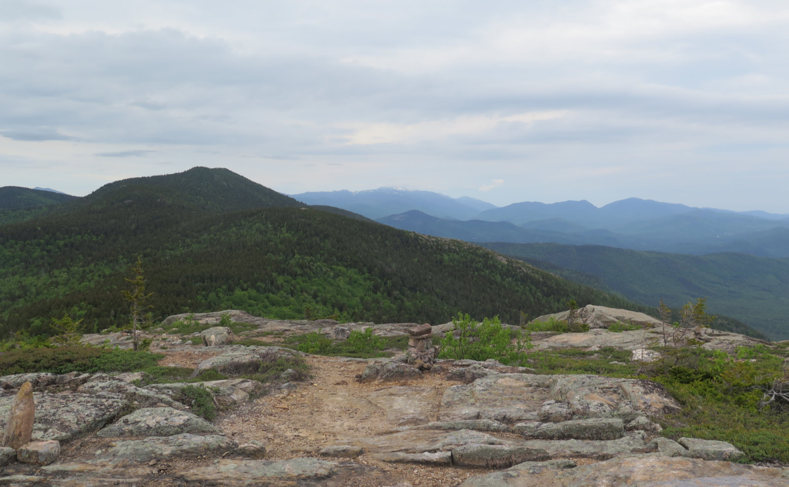
The mountains were formed by volcanoes around 175 million years ago, and in the mid-1800s, the summits burned, and have been mostly bald since then. Perhaps a good thing, because they’re naturals for inclusion on the 52 With A View list. There are summits with a clearer view of the surrounding mountains. But the Moats are in a great spot, and what you lose in terms of being able to spot the further peaks, you gain in being intimate with so many others. At times, I felt like I was in the midst of a sea of mountains, with the landscape undulating everywhere. But more on that shortly.
The drive-in was scenic in its own right. I came in via Meredith and Tamworth, and so enjoyed views of the lake, and then of Chocorua. Closer to Moat, things turned to small farms, and just generally bucolic small town living. It was a nice lead-in to the day. Then, once I passed the trailhead, it was a short hike to arrive at Diana’s Baths. There was a small sign describing the site’s former use as a mill, and so I’ve got more about the Whites to research. Water cascaded down, and while it’s not a roaring volume, the rock itself had been impressively scoured over time. Various curvaceous surfaces betrayed the cumulative work done by erosion. You don’t think of tiny grit being all that powerful until you see stuff like this. Wow!
After the cascades, things got much more serious. The trail pitched upward significantly, and before long, I was starting to feel the burn. It’s not like the trail suddenly became the local equivalent of Valley Way or the Blueberry Ledge trail, (or heck, the top half of Desolation) but it did make a much more direct route upward. This is no lazy trail.
That’s not to say it was all work and no play. On the contrary. It’s nearly the official start of summer, and fittingly, the flowers are blooming. In particular, there seems to be a local maximum of rhododendrons. No kidding, there may be fewer rocks on that mountain than there are purple flowers. Oddly, I didn’t see much in the way of trilliums (of any variety) but I did see a fair bit of chokeberry, a few (you gotta look for them) pink lady slippers, and some diapensia.
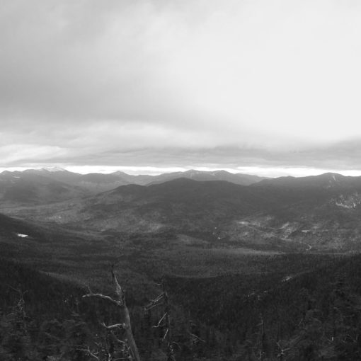
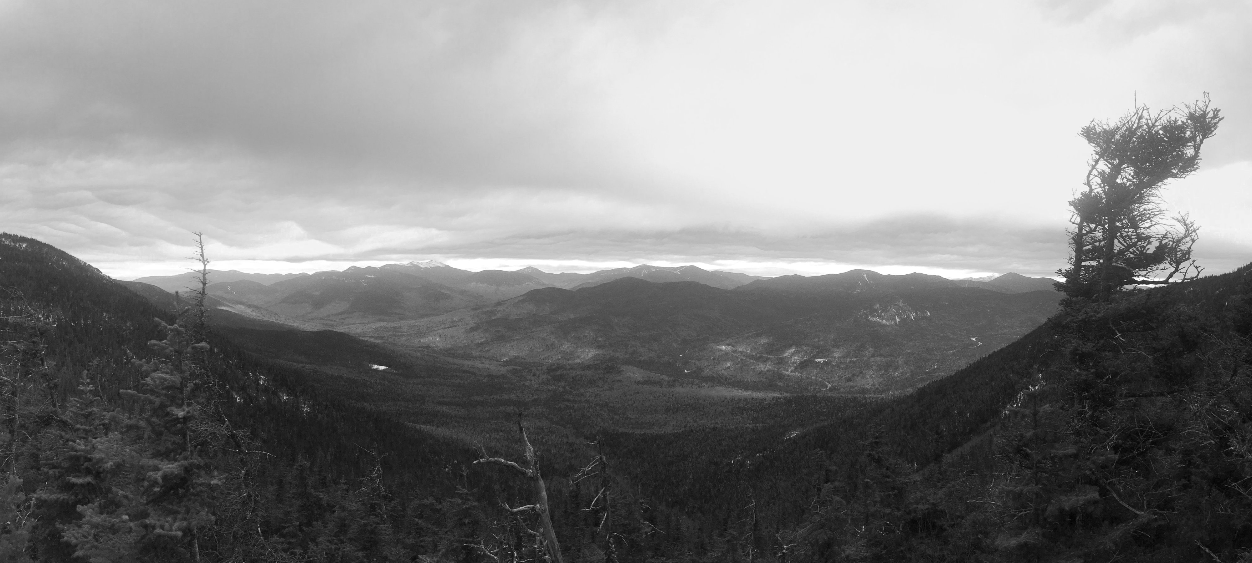
And then there were the views… oh my, the views. To the east, it’s pretty tame. When things open up, you get stellar views of Cranmore ski area, and then things level out fairly quickly in Maine. Some smaller stuff, but while Old Speck is visible to the north, it’s just a… um… speck, on the horizon. Unfortunate, because that one was a very fun, very memorable hike on a very nice mountain.
But there are three other compass points, and hoo-boy, if the visibility is even barely reasonable, you’re in for a treat. Today was a little too hazy to get the kind of definition I’d have preferred, but it was still enough that knowing Carrigain was “over there”, I could mentally clean things up enough to perceive Signal Ridge. And so on.
Washington wore a hat for a couple hours, but as I summited, those clouds dissipated, revealing a whole lot of snow still on those slopes. Madison was visible, and in the foreground, Wildcat and then Carter Dome from the back side. For me, it was an interesting view, because I’d only ever seen Carter Notch from the west, excepting those times when I was standing above it. And of course, the Sandwich Range area was well represented. Tecumseh was easy to spot, as were the Tripyramids. Passaconaway is just as huge from Moat as it was from Square Ledge. And Chocorua proved that one of the best ways to enjoy that mountain is to hike something else nearby, so you can gaze upon its majestic form.
Hiking over to Middle from North was easy, but not without its defining experience. Starting out on the trail first thing in the morning, you quickly learn that spiders like to span the trail when making their webs. I never expected that “pleasure” to extend well into the afternoon, but it did, several times, and it wasn’t just the silk that got all over my face. When it became obvious that it wasn’t going to get better, I walked with my hiking poles held up in front of me. It was the only way, and it went on for what felt like an eternity. Or at least ten to fifteen minutes. Which is the same thing as an eternity when cobwebs to the face are concerned. It might even be a double eternity. At least.
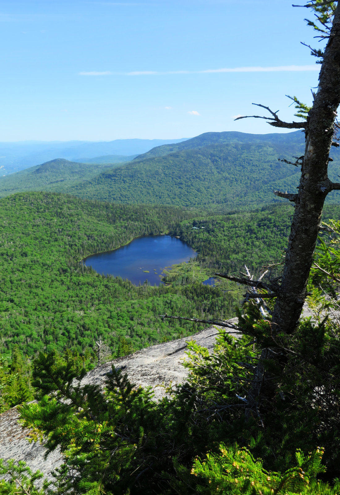
But all things come to pass, and spider webs are no exception. I summited Middle Moat. Looking at the map when I started out, I was concerned, because it’s a bit ambiguous as to where Middle ends and South Peak begins. The col between the two isn’t terribly deep. But then I was standing up there, and saw that yes, it’s very distinctive. Middle Moat has a broad area that makes finding the actual high point a bit of a trick, but a peek at my GPS made it clear. And the views got a little better, because now I had a shot of North Moat with Mt Washington and Carter Notch in the same view.
Heading back, I had to partly ascend North Moat. The key point is “partly.” I might have gone up about half a contour interval, but in contrast to the steeps I encountered on the north side of the mountain, this was much easier. I got to the trail junction and turned right, descending back to the trailhead. Overall, Red Ridge trail felt a lot more rough and rocky than Moat Mountain trail. Again, not even close to something like the northern Presidentials, but I think I rock-hopped a lot more than when I was heading up. Compounding that, I ended up looking around for blazes a bunch more. I had to turn around and find a blaze for the opposite direction much more than I’d have preferred. But that trick worked well, and I made my way safely down to my car. One thing for sure, I never felt like I’d get lost. It was stuck in my mind that if I ever needed to, I could just walk in a straight line, downhill to the east, and in a short bit, I’d be standing on the side of Route 16 in Conway. For a lazy-day hike, Moat has a lot going for it, and not the least is the sense that civilization is nearby.
I think it’s folly to think that just because Moat is a shorter peak, that it’s somehow easier. While it’s not something really hard like Tripyramid’s slides, it’s still got enough meat on its bones to show any hiker a fair challenge. It won’t crush you, but you’re going to have to push fairly hard in order to succeed.
But wow, the views from the top of either peak are so worth it.
As always, stay safe out there.


Nuts and Bolts: The easiest way is to follow Route 16 in North Conway to West Side road, and then follow the signs to Diana’s Baths. You’ll be very near Whitehorse Ledge, so further out, following those signs won’t steer you very far wrong.
Trailhead will be at the far end of the parking lot, near the iron ranger. Blazes are yellow, and there are cairns up above tree line. Note that in certain spots, you might find there are fewer of either than you’d prefer. Move carefully, and look behind you to a blaze on the opposite side of a tree, and you should be able to piece things together. Be aware that while water is amazingly plentiful in the lower reaches of the mountain, once you move away from the obvious sources, that’s about it, so top off your supply early.
2 thoughts on “Trip Report: Amazing Views From Moat Mountain”
Hi, I met you on Mt. Tom once a few years back. I do enjoy your writing style and photos. I had a toe surgery almost two years ago which is finally healing enough to start hiking again. During my down time reports like yours kept me “out there” a bit. So Thanks for that! You have a keen eye for the interesting and a playful way with words that I appreciate . Thanks again, Emerel
Greetings! I had a similar mishap in December, when I broke my ankle on Mt Adams. I know first hand how frustrating that convalescence can be, and how quickly the walls start to close in. I hope you’re back on your feet soon. Glad you’ve enjoyed the posts, and it’s heartening, hearing they’ve lifted your spirits and kept you feeling connected.