Mt Monadnock (3,165 feet). Dublin, NH. 2020-07-02 (Thursday.)
Via Dublin Trail. Approx 5 miles round-trip. 1,750 feet elevation gain.
78 dF at the trailhead, 80 dF at the summit. Winds were negligible in the trees, about 5 knots at the summits in the exposed areas. Sun and clouds throughout.
Trailhead: 1230. Summit: 1400. Car: 1520.
A quiet walk to a crowded summit
Seeing a potential for thunderstorms will put the kibosh on the best laid plans. Like most everyone else, I’m deathly allergic to being electrocuted by millions of volts on a mountaintop (or anywhere else, for that matter) and so when I saw that in the forecast, my idea that I might hike up Mt Wolf was scotched. And that was a bummer, because I wanted to hike to Eliza Brook and finish redlining the Kinsman Ridge trail. But there it is. So what to do?
Scanning the forecast, it wasn’t looking favorable to blow the day driving up to the Whites, so I looked closer to home. And that’s when I realized there were a few trails, notably those on the north side, on Monadnock that I wanted to do. So I randomly chose Dublin, and headed out the door. Bonus was that I’d get a hike in, and still have the rest of the day to putter around the house, getting a few things done. More on that later.
It’s a mountain of so many differences
When I was in college, I’d spend the night with friends drinking absurd quantities of Mountain Dew, playing cards and board games into the wee hours. We’d crash for a few, then awake and get to the White Dot trailhead bright and early. Nail the summit, and then descend as the normal people were on their way up. I don’t know how many dozens of times we did this, but it was an “every weekend” thing for several summers at least. And there were those times we portaged a canoe to the summit and back. Because it’s there.
But then sophistication crept in… what about other trails? And that’s when I started taking the Cascade Link trail around the side, or parking at Birchtoft, or cross over and come down Parker Trail. In general, changing things up a little. But somehow, that north side got left out of the equation. And that sat in the bottom of a locked filing cabinet in the back of my mind until this season, when I started addressing the stuff closer to home,and most decidedly “down south.”
That changing things up, however, introduced me to one important point that I’ve never forgotten: the mountain has differences. You hike the same thing every time, eventually, you get past the “gotta watch where I’m going” and start looking at the scenery. And I began noticing the forest near the White Dot/White Cross looks one way. But it’s different by Spellman. And it’s different by Smith Summit. Wow! And now, I can confirm, coming up from Dublin is… also different. Vive La Différence!
An easy trail invites contemplation
Going by the book, it’s the easiest trail on the mountain. And going by my boots, I’ll buy that. I started out with a fairly smooth trail cushioned by duff, ascending by gentle grades. I think it was three drainage crossings, and each of them was very neatly lined, either side, with flat rocks for easy passage. It got a little rooty, and then after a spell, got a bit rocky. The grade pitched upward, but not insanely so — this is sooo not the White Dot trail with its mad 900 feet per mile ascent rate.
I had a lot of time where I didn’t have to watch my footing. It’s true that in the upper reaches, it gets rocky, and there’s a good bit of rock hopping, but overall, it’s a fairly easy trail. Lots of time to look around, and appreciate the sunlight dappled through the trees. Some nice mossy bits in the mid-elevations. And approaching tree line, there’s quite a spell when the blue of the sky pokes through the canopy. And all the while, for the most part, it’s a fairly open understory, so there’s a lot of looking around.
One thing I didn’t see much of were wildflowers. There were what I’m pretty sure was rhododendrons or mountain laurels of some sort at the treeline. There were also some cinquefoils in odd gaps between the stones nearer the summit. But other than that, it was mostly ferns. No small number of trees, and some older-growth ones at that. But this wasn’t the wildflower-fest that I’ve enjoyed on other mountains.
I got to the summit, and there were the expected crowds. At the moment, NH State Parks has instituted a policy where parking at the Poole Road entrance and the Old Toll Road is by reservation only. (See below.) The knock-on effect is that the summit, while nominally covered with people, had the feel of an early morning, despite being mid-afternoon 2 days before the Fourth of July. It certainly wasn’t the normal sea of bodies. I never imagined I’d see that, yet I didn’t linger. I grabbed my summit selfie, and headed back down, happy to spend no real amount of time up there today.
Oddities abound
It’s a very straightforward trail, and it gives me a good reason to hike up from the north way more often. While I lose the vistas from the White Dot side, there was still plenty to see, although those views came almost entirely toward the end. Overall, though, “straightforward” is a synonym: I found it entirely in line with my experience on the other parts of the Monadnock-Sunapee Greenway. Which is appropriate, seeing as this was the southern terminus. By another comparison, I’m left feeling it was like a bigger version of hiking up Pack Monadnock. Which is totally fine by me — I made a new friend in that trail today.
About half a mile up, there was this weird bit where I made a right turn and emerged on a logging road… that lasted about 150 yards (or, about 130 paces. Yes, I counted, because it was that weird, being so obviously short.) And there were those drainages which were so meticulously crafted, with the flat rocks lining each side. Almost paved. I suspect as I hike this one more, I’ll find other oddments here and there.
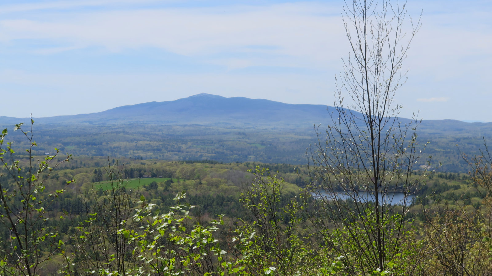
Nearer the top, a nice view was had by going off-trail about a couple dozen yards or so, to a ledge that overlooked (I think) Antrim. There were wind turbines, and I could see out to at least Kearsarge before the haze started clipping the view. (And it was remarkably hazy today.)
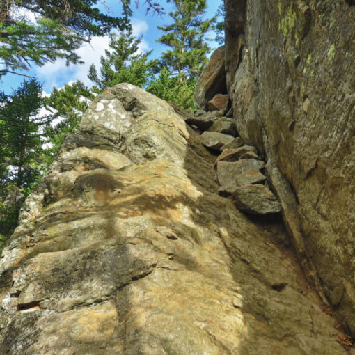
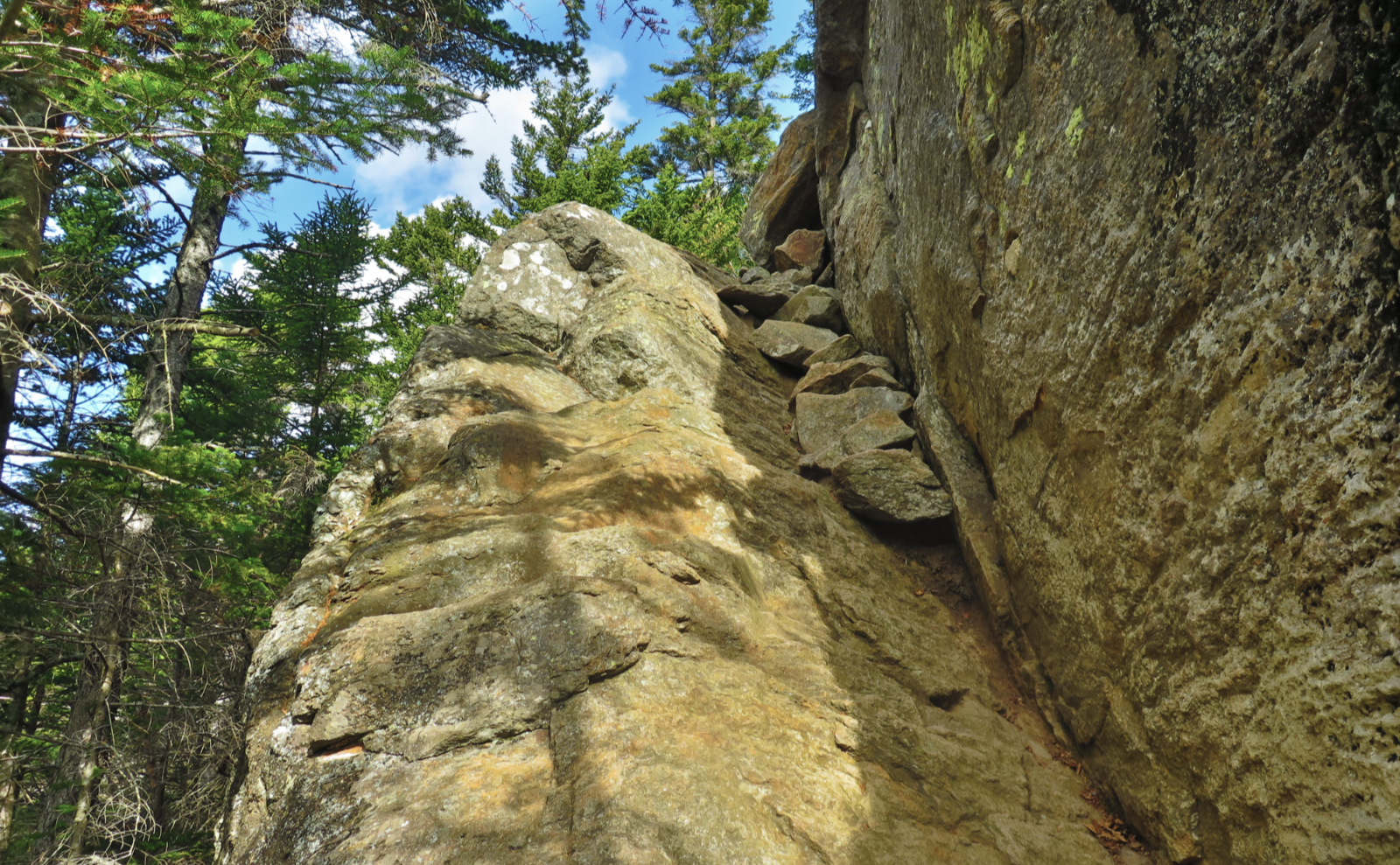
Then in the uppermost bits, some of the larger slabs showed signs of weathering, notably the path rainwater would scour the rock. Not all of it took the straightest path, and it made me wonder what caused those undulations over so long of an amount of time. As often as I climb this mountain, it’s the story told by those rocks that catches my eye every single time.
And so there it was.
On the way home, I stopped at the Dublin General Store. It’s a tidy little sandwich shop. The beverage coolers have less of a selection than you might want, but there’s certainly enough, and probably the smaller selection makes your decision quicker and easier. Then a bit further down in Wilton, I stopped by the House By The Side Of The Road. Their flowers are still very much in bloom. I spent most of an hour wandering the greenhouses, seeing their enormous koi in long, bubbling pools. Gravel crunching underfoot, heady aromas of all make and sundry of plants. If the hike wasn’t enough relaxation, this was certainly the icing on the cake. It was a good day out.
As always, stay safe out there.

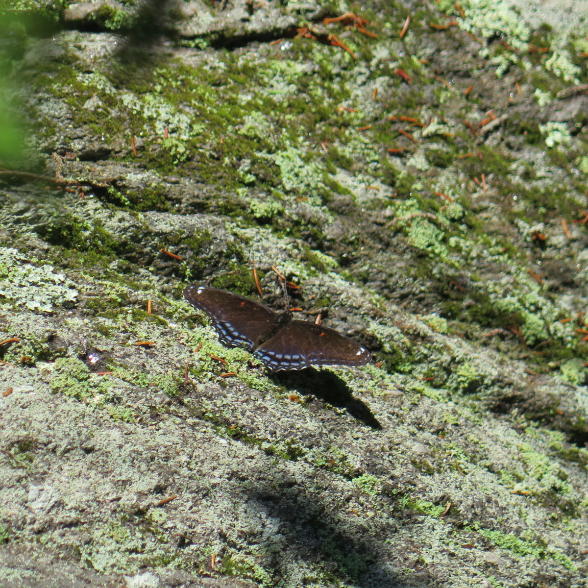
I’m still trying to identify this one. Arrgh! And as usual, the Eastern Tiger Swallowtails didn’t hold still for a picture. Double Arrgh!
EDIT: It’s a Red Spotted Purple. (Limenitis arthemis ssp.astyanax)

The trail down low was pretty sedate. Lots of greenery.

A bit higher, roots. And moss. Lovely, lovely moss, softening the landscape under a verdant duvet.

Things got slabby, and in the shade, rocks were sweaty and in some cases, slippery. Watch out!

A meandering rivulet.

Maybe not glaringly obvious, but there were curvaceous undulations that suggested the flow of water. Time and tide washed the stone away.

Some people on the summit, but far fewer than normal.

Quoth the corvid “feed me more!” I was amazed at how much this fella tolerated the crowds. Not 100% positive whether it was a raven or a crow, but in flight, its tail feathers were more like a crow. A corvid just the same.

Summit Selfie! First of the year, and it felt good to be back.

Looking out over Dublin Pond.

Looking to the west of Dublin Pond.

Jim’s Junction.
Nuts and Bolts: Hop on Route 101 as if you’re going to the Poole Road entrance. Where 202 splits off to the left in Peterboro, keep straight and stay on 101. In Dublin, watch for the flagpole near the Universalist Church, and trip your odometer. About half a mile down, turn left onto Lake Road. The turn itself is at the top of a hill, just a hair past your line of sight, but there’s a yellow sign a bit beforehand to forewarn you. Just under a mile later, Lake Road takes off to the right. Keep going straight onto Old Marlboro Road. Then just under a mile after that, look for Old Troy Road on the left. It’s a dirt road that drops down just as you make the turn. You’ll follow this for 1.7 miles, and the trailhead parking will be on the right. Note that the trailhead itself is on the left side of the road. Overall, if you turn onto Lake Road, follow your nose, then turn onto Old Troy, and follow your nose, you’ll get there. A couple of the distances make you wonder, but as long as you don’t go more than about 4 1/2 miles, you’re probably on the right track.
Blazes are white rectangles, mainly the familiar 2×6 inch format, although you’ll find some white “D” blazes here and there above treeline. Near the summit, pay attention to where you are, because coming down… route finding isn’t hard per se, but it’s very wide open up there and it could be easy to go the wrong way by mistake. If you’re very used to the White Dot side, this has a different feel. Keep good awareness and watch out for cairns and blazes, and you should be fine.
SPECIAL NOTE ABOUT PARKING: Due to COVID-19, parking at Poole Road and the Old Toll Road areas is by advance reservation only. No reservation means they will turn you around and send you home, because everyone else has gone online and gotten themselves a reservation. (Military/vets, seniors, and license plate/season pass holders have a chance at a few spots held open based on seasonal averages, but these are not guaranteed.) If you’re a season pass holder, they encourage reservations, and there’s a mechanism for reimbursement until they hammer out the “features” in the system. Call the park for details.
On the Dublin Road side, this restriction isn’t in effect, but at the same time, the parking lot is very much smaller — perhaps 12-15 cars or so — and I wouldn’t assume the locals won’t arrange to have your car towed if you park along the roadside. The road itself isn’t all that wide and besides, the shoulders are soft. Don’t be that guy. Instead, be an ambassador for the sport.
3 thoughts on “Trip Report: The road less traveled. Hiking Mt Monadnock from the north”
Hi, does coming from this entrance require fees to park?
As I recall, the iron ranger was covered with a black plastic trash bag and duct tape, with a sign saying fees were being waived at this time due to COVID. That said, I’d arrive prepared with fee in hand, of course.
Thank you. I planned out a lollipop loop and may go this coming Monday.